
Welcome to the second post in our blog series that explores the power of mapping and GIS in supporting Indigenous Nations to advance their rights and interests.
In this story, we explore how Wasauksing First Nation used GIS and a custom-developed app for their Aquatic Monitoring Program (AMP). Daniella Baker, the Lands Manager, was thinking of ways to make it easy for the land users to record what they were seeing out on the water. Read on to see how technology can make mapping life easier!
Wasauksing's Aquatic Monitoring Program
“I wanted to create an easy-to-use App that would provide our community members with the ability to capture real-time data while they were out on the land as opposed to having to call in the information.”
– Daniella Baker, Lands Manager, Wasauksing First Nation
One area we focus on at SVS is sustainability – not just environmental sustainability but project sustainability: our ability to work ourselves out of a job. How can we empower Nations to maintain momentum on a project after our role in it ends? This is a question we think about a lot.
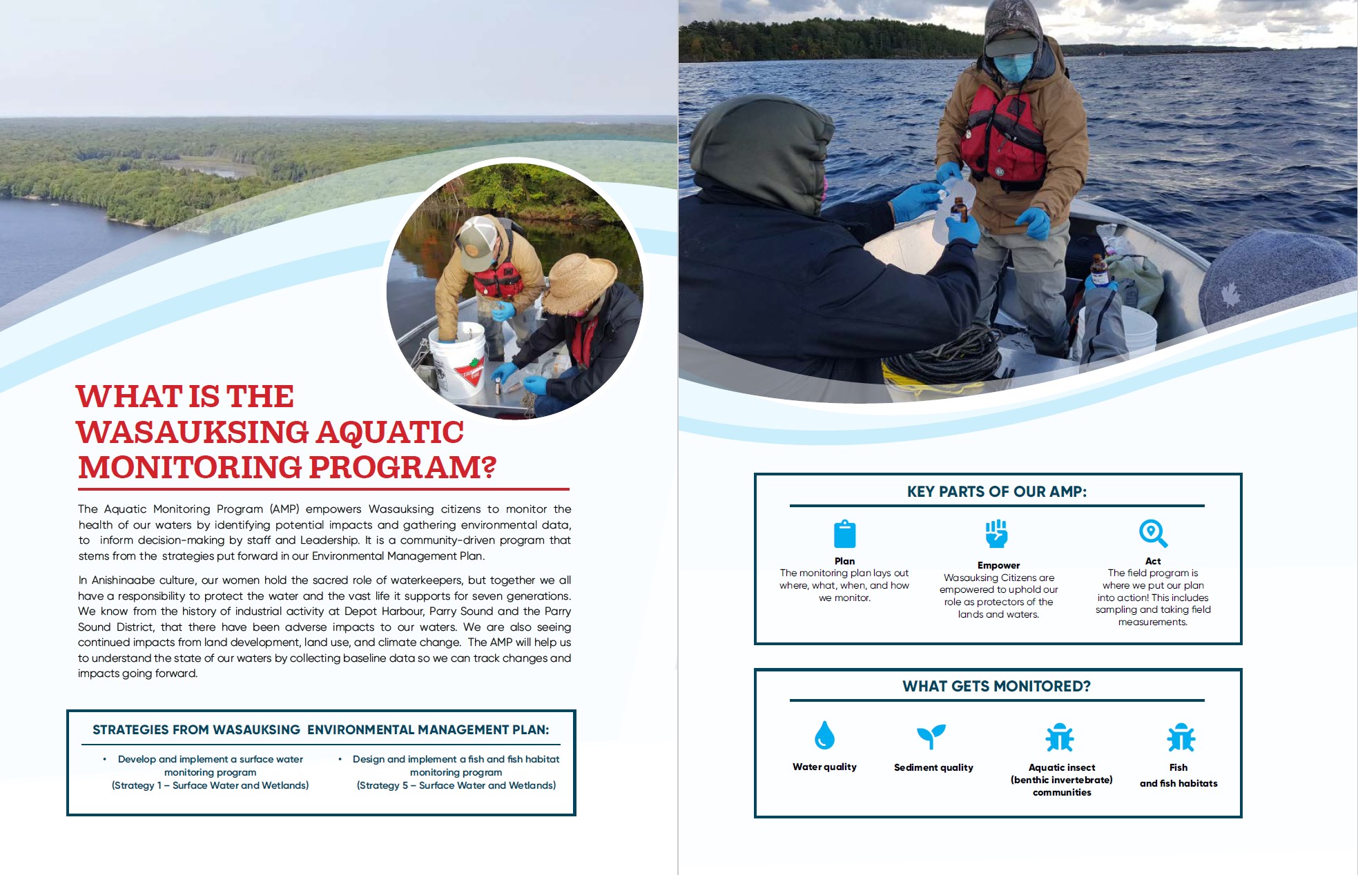
The water within Wasauksing First Nation’s Traditional Territory has been stressed for generations by historical and current industrial operations, climate change,
.jpg?width=334&name=WASAU_Garmin%20GPS%20(002).jpg)
land use change, aquaculture operations, agricultural practices, and residential developments. Protecting the nibiish (water), and all life it supports, such as fish, is a priority for Wasauksing citizens. One way Wasauksing decided to enact this priority was to develop an Aquatic Monitoring Program (AMP) to monitor and assess the long-term health of the aquatic environment. This way, Wasauksing can collect baseline data and evaluate changes over time.
SVS’s involvement in Wasauksing First Nation’s AMP was meant to help develop the program and get it up and running in Year 1. But then what? Beyond training, we worked closely with Daniella and her team to integrate ideas and develop tools that would help grease the wheels on the program in future years. Key to these tools were geographic information systems (GIS) and mapping technologies.
Data Collection App
The pandemic allowed us to pivot from thinking solely about Year 1 of the AMP by instead letting us focus time and resources on how Wasauksing could maintain momentum with this work in future years. Year 1 of Wasauksing’s AMP focused on ten monitoring locations, but the community expressed a desire to expand this program in the future. Citizens wanted to know how their knowledge and experience on the water would help inform their AMP beyond the initial community engagement. One idea the Lands Department came up with was a data collection app customized for Wasauksing:
“I wanted to create an easy-to-use App that would provide our community members with the ability to capture real-time data while they were out on the land as opposed to having to call in the information.” – Daniella Baker, Lands Manager
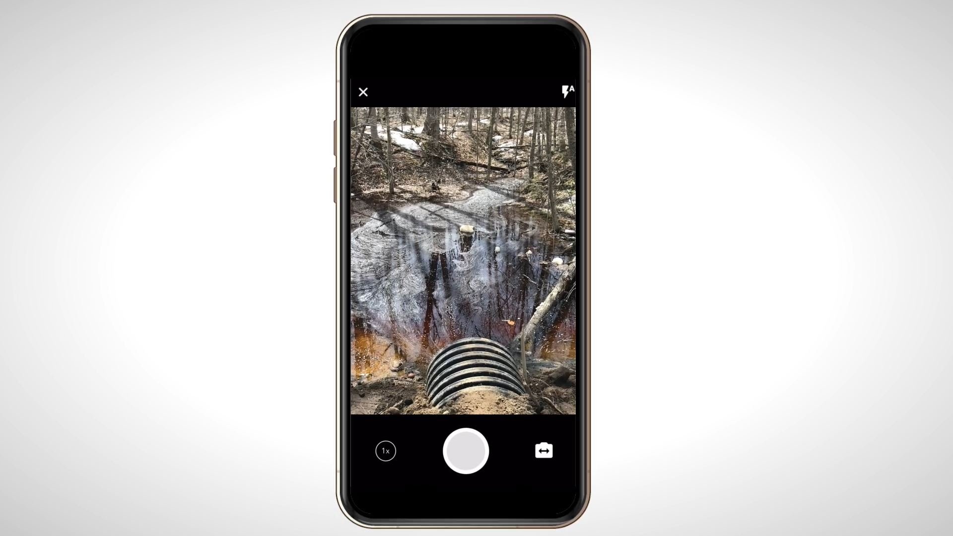
 The app was customized in QuickCapture, an Esri ArcGIS product for field collection, which is available for download for free on the Google Play (Android) or Apple App Stores (iPhone). We created a short instructional video and paper instructions to show Wasauksing citizens how easy it is to download and use the app.
On the water, it allows Wasauksing citizens to mark important features, changes they notice or places they would like monitored in the future. It marks the location of the feature by GPS point and also gives the opportunity to add a photo and notes explaining what you’re marking down. That way, decision-makers will be able to use citizen-sourced information in the AMP’s development.
On the back end, all Wasauksing needed was an Esri subscription to have access to customizing and hosting the app. In the office, Daniella and her staff can see the data populated in real time on a map and in a searchable database! Data is power. Having this data at their fingertips will help Wasauksing staff grow and expand this program and make informed decisions for their Nation.
The Right Tools for the Job
Having the right tools in-house can make all the difference when training staff to carry out a monitoring program. When monitoring equipment is community-owned, it can be readily accessed by staff to provide training, develop maintenance and calibration skills, and become familiar with the full array of capabilities these tools have to offer. Renting field equipment can be a tricky business dealing with shipping delays, poorly maintained instruments, and sometimes, receiving the wrong equipment leaving you scrambling on field day.
As part of the AMP project, we worked with Wasauksing to secure key pieces of equipment that would be pivotal for the project’s success now and in the future.
“For Wasauksing, having our own equipment to carry out our sampling program (surface water and sediment) provides us with autonomy over the data collected and autonomy over the program. Once we've been able to establish a baseline of data, we can begin to determine additional sampling sites or frequency of sampling. Having our own equipment gives us that freedom.”
– Daniella Baker, Lands Manager
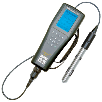
Wasauksing purchased three key pieces of equipment: a GPS unit, a
YSI water quality meter and a Petite Ponar.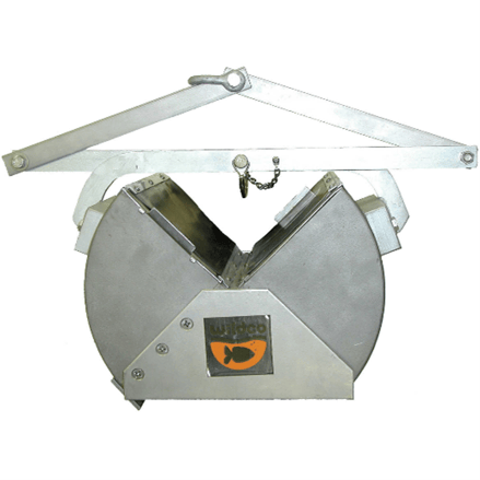
GPS Unit
The Garmin GPS unit allows Wasauksing to accurately identify and map monitoring locations connecting their in-field work with their desktop GIS data.
YSI Water Quality Meter
Wasauksing’s YSI water quality meter is an essential piece of equipment for this work — a portable handheld instrument that can measure pH, dissolved oxygen, and conductivity all at once!
Petite Ponar
Finally, the Petite Ponar, while not only a fun name to say, is used to grab sediment samples from the lakebed for further analysis.
Communications Tools
The project team hoped Wasauksing citizens would be just as excited about this project as we were. But first they needed to know about it. During pandemic life, it has been challenging to share, experience and celebrate as a community. So Wasauksing knew they would have to put some more effort into communicating the results of Year 1 and how citizens can participate in the AMP as restrictions ease up.
We worked in partnership with Wasauksing and Vincent Design, a Winnipeg-based creative marketing company that specializes in graphic design. Together, we created a brochure and a web-based version for the project. Wasauksing citizens have told us they love maps of the Island. So, the mapping features place names in Anishinaabemowin based on information provided by Wasauksing citizen Brian MacInnis in his book Sounding Thunder: The Stories of Francis Pegahmagabow.
Not only will the brochure providing learning opportunities for citizens, it also explains how they can participate in the project by becoming monitors or downloading the app and sharing information with decision-makers. It’s a win-win opportunity for citizens, staff and leadership.
All together, the app, plus the right tools, community engagement and the Aquatic Monitoring Plan itself, complete the recipe for success for years to come.
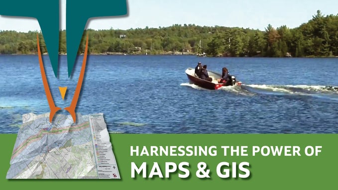
Blog Series: GIS and Mapping
Harness the power of the map for better, more informed decisions
Welcome to our blog series that explores the power of mapping and GIS in supporting Indigenous Nations to advance their rights and interests. GIS stands for Geographic Information Systems. Many of us know the term, but if you are fuzzy on what it actually means, you're not alone! Throughout this blog series and in our upcoming eBook we will explore what it is, how it works, and some of the amazing things you can do with it.
Other posts in this series:
GIS and Mapping Services at SVS
Our goal is to make it easy for your Lands Department to have control over your maps of your territory. Our services are scalable to your needs. We can come along side your team and support as you build in-house capacity, chose to outsource your mapping needs, or something in between. We leverage Esri ArcGIS tools to allow for accurate, real-time data collection, analysis, and more:
• Field data collection made easy
• ArcGIS StoryMaps
• Real-time data visualization
• Training programs
• And of course, any map you could ever need!
Read Our Full 2021 Services Brochure Here To Find Out What Other Great Services We Offer
Get more posts like this directly to your inbox! Sign up for our bi-weekly funding, news and information digest:

About Us: Shared Value Solutions
We are an Canadian B Corp, and we assist Indigenous communities with support throughout regulatory processes surrounding major development projects like mines, hydroelectric facilities, transmission lines, highway expansions, oil and gas pipelines, natural resource transport applications and nuclear power.
We have deep context and experience behind the recommendations we provide, having worked for our clients on almost every major project in Canada over the last 10 years. For us, it’s all about building long-term relationships with our clients. We want to get to know you and what you want to do so we can help you move your plans forward.
- Impact Benefit Agreement Negotiation Support
- Technical Reviews and Regulatory Process Support
- Community and Economic Development Planning
- Indigenous Knowledge and Land Use Studies
- Environmental Monitoring
- Guardians Program Development
- Climate Change Readiness
- GIS and Mapping
- And so much more: www.sharedvaluesolutions.com