
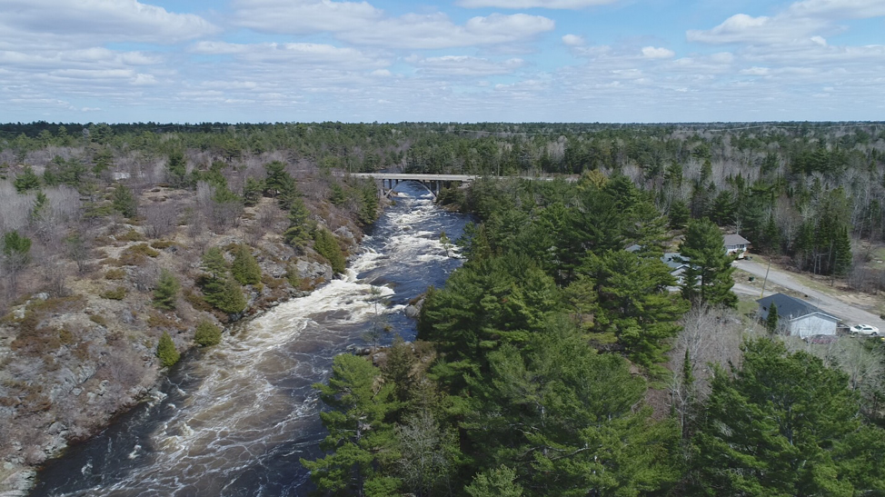
 The Magnetawan River surging with spring meltwater near Magnetawan First Nation, Spring 2019
UPDATE APRIL 2020:
Just because we're in the middle of this COVID-19 crisis doesn't mean rivers have stopped rising this spring. Whether by flood or by fire, many Indigenous Nations are facing the impacts of climate change. Last spring we discussed how floodplain modelling and mapping can be a powerful planning tool to tackling the flood problem head-on (see full article below).
Magnetawan First Nation Floodplain Mapping Almost Complete
As you can see in their new video, the floodplain mapping project we have been supporting Magnetawan First Nation with is nearing completion. Samantha Noganosh, Lands Clerk and Councillor at Magnetawan, reports that this year's flooding has surpassed that of last year, which was already a record. They are pleased to have this crucial information as they work on their land use planning.
First Nation Adapt Program: 2020-2021 Funding Still Available
Wondering how to fund a floodplain mapping project for your Indigenous Nation? Magnetawan's project was funded through the First Nation Adapt program.
This fund is still operating, although at a reduced capacity during the COVID-19 emergency. The good news is that there is still 2020-2021 funding available. While there have been minor, unpublished updates, the funders are directing communities to the 2018-2019 version for more information.
For a project to be eligible for funding under the Program, a project proposal needs to be linked to climate change risks related to infrastructure and emergency management and the priority areas listed on the website:
"The program prioritizes First Nation communities most impacted by climate change related to sea level rise, flooding, forest fires, drought, fisheries and winter road failures. The program provides support for communities to address project that include
risk assessments of climate change impacts on community infrastructure or emergency management. Communities experiencing these impacts are encouraged to submit a project description for funding consideration as early as possible to take full advantage of funding opportunities."
Please let us at SVS know if you could use some support with your application.
Original Post:
Indigenous Nations Prepare for High Waters
Every spring, a growing number of Indigenous nations face the threat of surging meltwaters, and 2019 has been no different. Kashechewan First Nation, a community that has evacuated residents every spring for 17 years when the Albany River floods, was forced to speed up evacuation plans this April because of the rapid melt of heavy snowfall. In Manitoba, compensation funds are finally rolling in as of last week for Little Saskatchewan, Dauphin River, Lake St. Martin, and Pinaymootang First Nations, who were forced to evacuate their communities due to intense flooding in 2011. The four communities won a $90-million class-action lawsuit against the Manitoba and Federal governments over the flood, which was caused by the diversion of water from the Assiniboine River to reduce flooding risk to Winnipeg.
Water is wonderful, water is unpredictable, and water is powerful. What are nations doing to manage the risks, while living with the benefits, of water?
If your nation has experienced the devastating impacts of flooding, you know that rising waters are a threat not only to lives and land, but to the mental health and wellbeing of everyone who endures the stresses of this forced relocation. With climate change set to exacerbate this problem, many nations are asking themselves, are we prepared for the day when the waters rise?
How can floodplain mapping and modelling reduce the impacts of flooding?
Some Indigenous nations are tackling the flood problem head-on through the use of a powerful planning tool: floodplain modelling and mapping. The results of floodplain mapping give you the ability to see what areas might be under water in the future under various scenarios – extreme storms, droughts or dam breaks, for example – and how likely these scenarios are to occur. Why is this tool so useful? Here are a few reasons:
- It can improve safety and emergency response planning. Floodplain modeling and mapping gives communities the ability to establish evacuation routes for a variety of potential future scenarios, such as extreme storm events due to climate change or potential dam breaks.
- It can super-charge land use planning. Using the model can help you to make critical land use planning decisions with high waters in mind, such as where to locate new infrastructure, subdivisions, or community buildings.
- It can help you make good decisions about adding new lands. As communities take advantage of opportunities from land claims, addition to reserve initiatives, and other ways to acquire new lands, flood plain mapping can help you avoid making bad decisions in favour of "high and dry" decisions.
- It creates great visuals to communicate risk. Floodplain modeling and mapping produces great images that can be very useful for communicating flood risk to your members. They might think better of building that cabin on the floodplain, for example, if they see the land potentially under water.
How is floodplain mapping done?
At SVS, our approach to floodplain mapping includes both scientific modeling and community knowledge. We work closely and collaboratively with the lands department, often conducting the research and interviews together. Read on for an overview of the steps involved.
Step 1. Gather elevation data of the land
First, collect the elevations of the floodplain and important structures, such as homes and doorsteps. The high-accuracy elevation datasets you need are already available in some areas from various sources (e.g., LiDAR data, which is a surveying method that sends out pulses of light, usually from an airplane, to measure elevations). Second, ground truth to verify the high-accuracy datasets. This means manually surveying elevations and gathering information through community interviews and walkabouts with members that can help identify high water marks out on the land.
Step 2. Gather elevation data under the water
Gather the elevation of the bottom of the river from existing datasets or by going out in a boat and collecting it with sonar equipment.
Step 3. Build the model
Create and test a digital flood model. Verify the results of the model with community members, and adjust the model accordingly.
Step 4. Run scenarios and produce maps
Once the model is built, you can run a variety of scenarios to see the effects of flooding on the community. For example, you can model water levels during extreme storm events, droughts, and dike and dam breaks. Floodplain maps can be created from the model results so you can visualize the extent of the water’s edge in each scenario.
Step 5. Use the results to inform land use and emergency plans
Finally, use the results of the model to adapt land use and emergency response plans to ensure your community is prepared for the future.
How can our nation fund this work?
Good news! While federal funding for floodplain mapping has been allocated for the 2019-2020 fiscal year, funding is available for the 2021-2022 fiscal year through the First Nation Adapt program.
Indigenous Planning Blog Series
This is the seventh post in a series that explores ways Indigenous communities have used the planning process to create an exciting vision for their future and a realistic roadmap to get there – and some resources and ideas for you to do the same. We hope you join us for the rest of the ride. And please get in touch if there’s a topic you’d like us to explore.
Read more posts in this series:
- Five Crucial Elements Every Land Use Plan Needs
- Three Questions to a Clear Vision
- Background Info Check List
- Indigenous Planning Cheat Sheet: Five Types, Tips and Resources
- Indigenous Nations Lead the Way in Marine Planning: How to Get Involved
- How to Use Video for Maximum Impact
Looking for floodplain mapping and modelling help? Or other planning help?
If you are trying to figure out how to get started, do give us a shout. We’d be happy to discuss your options and help you weigh the pros and cons of your planning options. We’re a team of self-proclaimed planning geeks who love to talk about this stuff, so don’t hesitate to get in touch.
Looking for a quick overview of some planning options you might be considering?

Like what you're reading? Get future posts delivered right to your inbox:

About Us: Shared Value Solutions
We are a Canadian B Corp, and we assist Indigenous communities with support throughout regulatory processes surrounding major development projects like mines, hydroelectric facilities, transmission lines, highway expansions, oil and gas pipelines, natural resource transport applications and nuclear power.
We have deep context and experience behind the recommendations we provide, having worked for our clients on almost every major project in Canada over the last 10 years. For us, it’s all about building long-term relationships with our clients. We want to get to know you and what you want to do so we can help you move your plans forward.
- Reviews of Environmental Assessments and Environmental Impact Statements
-
Strategic Regulatory and Environmental Assessment Process Support
- First Nation Land Code communities
- Indigenous Guardian programs
- Impact Benefit Agreements: technical and regulatory support for negotiations
- Indigenous Jurisdiction initiatives: joint management agreements and co-management agreements
- Community-based Indigenous environmental monitoring
- Indigenous Land Use Planning
- Participant funding negotiation and application support
- Multimedia Storytelling